 The Leek
Allium porrum, a member of the onion family. Phoenicians are said to have introduced the leek to Wales when they were trading for tin in the British Isles. Sometimes called “poor man’s asparagus”. According to legend, the leek is linked to St. David because some 60 years after his death, in 640 AD, the Briton King Cadwallader ordered his soldiers to wear them on their helmets when they fought a victorious battle against the pagan Saxons in a field full of leeks. They subsequently gained a great victory over their enemies.
On St David’s day, wherever the Royal Welch Fusiliers happen to bein the world, in peacetime or at war, leeks are worn, and the day observed, as far as possible, as a holiday and leeks are eaten in the Officers’ Mess.
The reverse side of the 1984 British £1 coin has an image of a leek on the reverse side.
Daffodils
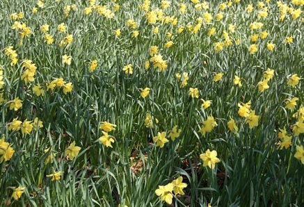 Some say the reason why the daffodil is used a Welsh emblem is that the word for daffodil and for leek are the similar in Welsh – Cenhinen = Leek, Cenhinen Pedr = Daffodil (more info here). This may explain why both have been adopted as our national emblems.
One species, Narcissus obvallaris, grows only in a small area around Tenby. In Wales it is traditional to wear a daffodil on Saint David’s Day (1 March).
In the language of flowers, daffodils signify chivalry and/or respect.
Harp
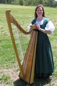 The Welsh Triple Harp has three rows of strings.the two outer rows are tuned to the diatonic scale (Like the white keys on a piano or keyboard) and the inner to the accidentals.The harp is usually rested on the players right shoulder, but Welsh tradition has always been the reverse, resting the harp on the left.
It is the Triple Harp which lays claim to the prime place in the history of the harp in Wales. This harp has three rows of strings: the two outer rows are tuned to the diatonic scale and the semitones are in the central row. This harp originated in Italy in the sixteenth century as a low headed instrument. Soon, towards the end of 1600s, it arrived in Wales where it developed a high head and was larger in size, and soon became known as the Welsh or Triple Harp. Triple Harp players are very rare. The Triple Harp’s name in welsh is Y Delyn Deires.
Dragon
Some sat that this symbol was brought to these isles by the Romans. The ancient welsh poets Aneirin and Taliesin used the Welsh word for dragon ‘draig’ to refer to Welsh warriors.
 The oldest recorded use of the dragon to symbolise Wales is from the Historia Brittonum, written around 820, but it is popularly supposed to have been the battle standard of King Arthur and other ancient Celtic leaders.
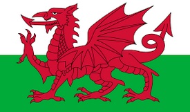
Adopted as an emblem by Edmund and Jasper Tudor it eventually became the symbol of Wales. The Welsh flag featuring the dragon was granted official status in 1959.
Y Ddraig Goch (Welsh for the red dragon) appears on the national Flag of Wales, and is the most famous dragon in Britain. There are many legends about y Ddraig Goch.
From the blog:
Famous People From Wales
Thousands of Welsh men and women have shaped history. Many are famous for their roles in science, art, sport and politics… Read more
Editor’s choice
Find awesome Valentine’s gift ideas for her here – tens of suggestions, tips and guides on how to turn the celebration into a memorable day!
Welsh Championship
Rugby is considered the national sport of Wales. The game was introduced to Wales at Lampeter College in the mid-nineteenth century… Read more
In the Mabinogion story Lludd and Llevelys, the red dragon fights with an invading white dragon. His pained shrieks cause women to miscarry and animals and plants to become barren. Lludd, king of Britain, goes to his wise brother Llevelys in France. Llevelys tells him to dig a pit in the centre of Britain, fill it with mead, and cover it with cloth. Lludd does this.The dragons drink the mead and fall asleep, and Lludd imprisons them, still wrapped in their cloth, in Dinas Emrys in Snowdonia (Welsh: Eryri).
The tale is taken up by Nennius in the Historia Britonum. The dragons remain at Dinas Emrys for centuries until King Vortigern tries to build a castle there. Every night the castle walls and foundations are demolished by unseen forces. Vortigern consults his advisers, who tell him to find a boy with no natural father, and sacrifice him. Vortigern finds such a boy (who is, in some tellings, to later become Merlin) who is supposed to be the son of a demon. On hearing that he is to be put to death to solve the demolishing of the walls, the boy dismisses the knowledge of the advisors. The boy tells the king of the two dragons. Vortigern excavates the hill, freeing the dragons. They continue their fight and the red dragon finally defeats the white dragon. The boy tells Vortigern that the white dragon symbolises the Saxons and that the red dragon symbolises the people of Vortigern. If Vortigern is accepted to have lived in the fifth century, then these people are the British whom the Saxons pushed back to the edges of Britain and who are today called the Welsh.

